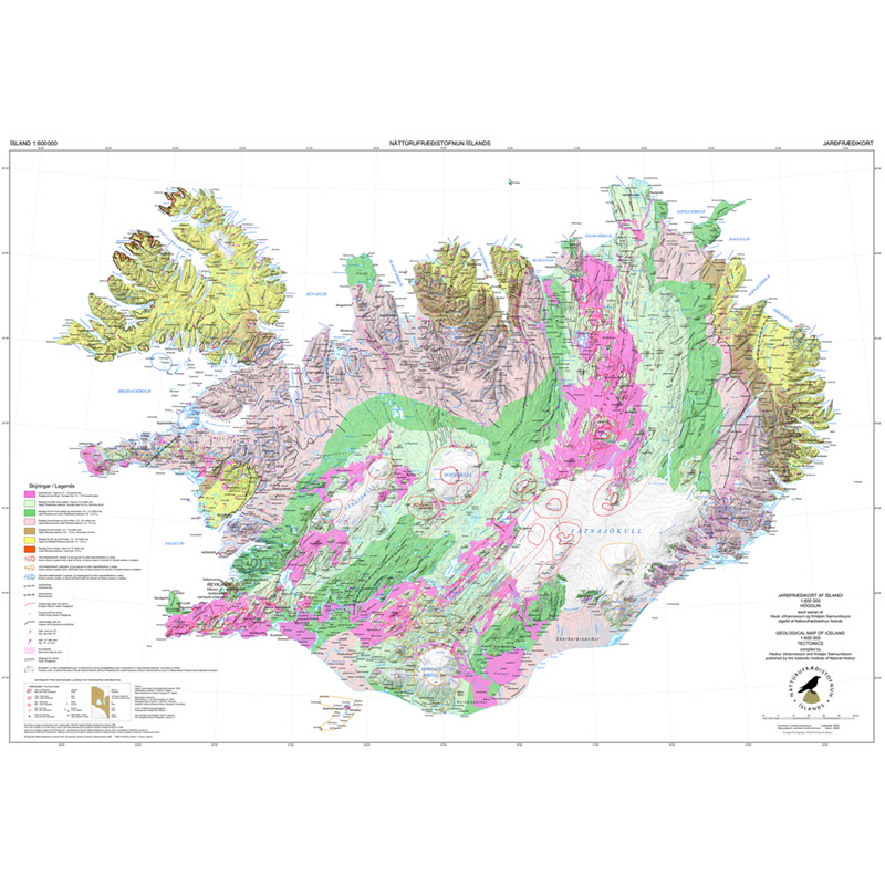
NI_J600v Jarðfræðikort af Íslandi – Höggun - 1:600.000
Gagnasafn (GDB) NI_J600v_hoggun: Jarðfræðikorti af Íslandi – Höggun – 1:600.000 [Geological Map of Iceland – Tectonics – 1:600.000].
Höggunarkort af Íslandi sýnir jarðfræði landsins á nýstárlegan hátt. Jarðlög eru flokkuð eftir aldri en ekki eftir gerð og samsetningu. Sýnd eru eldstöðvakerfi, þ.e. megineldstöðvar, sprungu- og gangareinar, bæði virkar og útkulnaðar. Einnig eru sýnd helstu brotakerfi landsins og halli jarðlaga. Kortið gefur innsýn í jarðfræðilega byggingu landsins.
[The Tectonic Map of Iceland gives a new view of the country's geology. The rocks are classified by age, but not by type or composition. Volcanic systems including central volcanoes, fissures and dyke swarms, both active and extinct, are shown, as are the island's principal fracture zones and the dip of rock layers. The map thus gives a useful insight into the geological structure of the country.]
Simple
- Date ( Publication )
- 1998-05-01
- Date ( Revision )
- 2009-05-01
- Identifier
- {7C7C80FC-4C63-4384-A3C9-F4580A298EB6}
- Status
- On going
- Keywords ( Theme )
-
- INSPIRE
- GEMET - INSPIRE themes, version 1.0 ( Theme )
- GSL flokkun ( Theme )
- Use constraints
- Other restrictions
- Other constraints
- http://www.ni.is/rannsoknir/landupplysingar/skilmalar
- Access constraints
- Other restrictions
- Other constraints
- no limitations to public access
- Spatial representation type
- Vector
- Denominator
- 600000
- Metadata language
- is
- Topic category
-
- Geoscientific information
))
- Begin date
- 1998-01-01
- End date
- 1998-01-01
- Reference system identifier
- EPSG / 5325
- Distribution format
-
-
ESRI Shapefile
(
10.2.0.3389
)
-
ESRI ArcGIS FileGDB
(
10.2.0.3389
)
-
ESRI Shapefile
(
10.2.0.3389
)
- OnLine resource
- Niðurhalssíða NÍ
- OnLine resource
- Vefur Náttúrufræðistofnunar: Jarðfræðikort ( WWW:LINK-1.0-http--link )
- OnLine resource
- Vefur Náttúrufræðistofnunar ( WWW:LINK-1.0-http--link )
- OnLine resource
- Fitjuskrá 600 Jarðmyndun og landmótun (PDF) ( WWW:LINK-1.0-http--link )
- OnLine resource
- Skilmálar (PDF) – Licence (PDF) ( WWW:LINK-1.0-http--link )
- OnLine resource
- Skoða gögn í landupplýsingagátt ( WWW:LINK-1.0-http--link )
- OnLine resource
-
j600v_halli_p
(
OGC:WMS
)
j600v_halli_p
- OnLine resource
-
j600v_einhallabelti_fl
(
OGC:WMS
)
j600v_einhallabelti_fl
- OnLine resource
-
0
(
OGC:WMS
)
j600v_hoggunAldur_fl
- OnLine resource
-
Nútímahraun_–_Postglacial_lava_flows64793
(
OGC:WMS
)
Nútímahraun – Postglacial lava flows
- OnLine resource
-
0
(
OGC:WMS
)
Fellingar jarðlaga – Bedrock folding
- OnLine resource
-
Eldstöðvakerfi_–_Volcanic_system38248
(
OGC:WMS
)
Eldstöðvakerfi – Volcanic system
- OnLine resource
-
Eldri_brotakerfi_–_Older_fracture_zones32556
(
OGC:WMS
)
Eldri brotakerfi – Older fracture zones
- Hierarchy level
- Dataset
Conformance result
- Date ( Publication )
- 2010-12-08
- Explanation
- Information required according to INSPIRE Geoportal Validator´s verification report. Validation has not been performed.
- Pass
- Yes
- Statement
- Tekið saman af Hauki Jóhannessyni og Kristjáni Sæmundssyni. Kortið var skjáhnitað 1997. Stuðst var við upplýsingar af berggrunnskorti 1:500.000 og jarðfræðikortum 1:250 000, blöð 1-3, 5-7 og 9. Útgáfan var endurskoðuð 2009 miðað við nýjustu upplýsingar um jarðfræði Íslands. Skekkjumörk kortsins eru +/- 500 m. Mælikvarði kortsins var upphaflega 1:500.000 en í útgáfu 2009 var mælikvarða breytt í 1:600.000 og sett sem 1. útgáfa. Gæði gagna eru þau sömu, en útgáfa höggunarkortsins er eftirfarandi: 1. útgáfu 1998 og 1. útgáfa 2009 í mkv. 1:600.000.
gmd:MD_Metadata
- File identifier
- {467EBAA3-E603-4E4C-A61F-2FFE9D19C11D} XML
- Metadata language
- en
- Hierarchy level
- Dataset
- Date stamp
- 2024-09-10T15:11:50
- Metadata standard name
- INSPIRE Metadata Implementing Rules
- Metadata standard version
- Technical Guidelines based on EN ISO 19115 and EN ISO 19119 (Version 1.2)
Overviews

Spatial extent
))
Provided by

 Lýsigagnagátt